Manhattan – 1886
Manhattan’s earliest roots are present not in the heritage of its American settlers, but in the fork of the Potawatomi Indian trial stretching from the Des Plaines River to the Kankakee River. The Council of the Three Fires used the area for hunting game and making temporary camps while travelling through the region.
The independence of the Ottawa, Chippewa, and Potawatomi would be encroached upon under the Treaty of St. Louis, which began a course of migration through the region in 1817, and when the area’s first inhabitants would settle in 1834 at the Five Mile Grove – along the crossroad of the Jackson Creek and Potawatomi Trail.
The sale of property by the United States’ government to fund the I & M Canal Project had brought Manhattan “to its rural roots and barn raising days” (Manhattan Township Historical Society. Manhattan Memories. Revised edition, 2017).
June of 1880 would bring an end to Manhattan’s seclusion, when the Wabash Railroad Company sent its first rail lines northward through the prairie towards Chicago. Unlike other rail lines, which transversed this underdeveloped region, the Wabash Railroad would establish a depot in the unincorporated area of Manhattan Township. The Wabash Depot would serve steam engines during the mid-nineteenth century with its pumping stations comprised of massive coal chutes and waterspouts.
At this point, the town’s sole business was in that of the blacksmith of William Trask, who had purchased eighty acres of land near the Wabash line in 1866, and whose singularity would be ceded by a class of farmers, stock growers, and dairymen, within the next decade.
Many entrepreneurs would make their mark on the village over the course of the late-eighteenth century, but forming Manhattan’s community can largely be attributed to the efforts of William McGowan to incorporate the small farming region. McGowan saw the depot as potential for promoting his own business endeavors and attempted to open a saloon near the Manhattan Depot. The resulting petition put Manhattan onto official county maps.
When the village would be incorporated in the year 1886, it would take its name from the township and grow to a population of fewer than four hundred people, with one hundred houses between them. Despite the meekness of this number in proximity to the nearby City of Joliet or even the rapid growth exhibited in Chicago, the spark when that first rail passed through the prairie would spawn a centuries long desire for economic prosperity in the heartland of America.
The efforts of Mr. McGowan would start a rapid trend of growth during the early twentieth century, bringing new vision to the area currently known as Time’s Square. Immigrants from Europe, local farming families, and ambitious entrepreneurs would bring about this development, creating a close-nit community based on “simple acts of kindness” and a “friendly spirit” (Manhattan Township Historical Society. Manhattan Memories. Revised Edition, 2017).
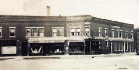
At the junction of the Wabash Depot and the intersection of North Street and State Street, the area now known as Time’s Square would be integral to forming this community. Framing the junction would be the Hoerrmann Hotel, a grandiose building constructed by a German immigrant family in 1906, which began as a bakery business run by Mrs. Anna Hoerrmannn in which one of the family’s sons would peddle baked goods from a covered cart taken around the village. The hotel’s theatre would be an epicenter for not only the performing arts, but also local gatherings. Plays were held in benefit of the local library, amateur shows would promote local talents, and recitals and graduation ceremonies would be held for an audience of up to four hundred people.
Flanking the opposite corner sits the Schroeder and Bergan building. This two-story building housed Schroeder General Merchandise – and the business of the Bergan brothers – an all-in-one general store for the local farming community offering a range of goods from candy to furniture. In its center, the junction would be home to a variety of businesses ranging from Prohibition-era taverns to a four-lane bowling alley. Its fluid change in businesses was due to a series of fires during the twentieth century which engulfed the closely pact structures; yet many of those owners would take their business and rebuild them from the ashes. That resilience of entrepreneurship would keep the community center alive for the better part of a century.
The Plan
The village of Manhattan announced a particularly ambitious plan to completely transform the outlook of its historic downtown over the course of the next twenty years with a focus on historical aesthetics, the stimulation of economic development, and connecting residents around a safe and accessible community center. In a press release, mayor Mike Adrieansen stated, “We want to honor our small-town heritage while making thoughtful improvements that create spaces for business, living, and community. Transparency and input from stakeholders are key to ensuring this vision reflects what matters most to our residents. Together, we can preserve our history and build a brighter future.”

The village’s ambition certainly reflects a desire to return to those roots, rekindling the local vivacity which had upbrought Manhattan during the last century; the demise of which began during the Great Depression, then with the failures of the Wabash Railroad System in the nineteen-seventies, and finally with the rapid suburbanization of Manhattan and its surrounding communities as of recent.
The master plan is tentatively divided between two sections of downtown. The first would be named the Wabash Corridor; a group of revitalized businesses wedged between historic State Street and the former Wabash railroad. And the second, Gustafson Grove; an area of new development situated adjacent to Central Park, which is currently the site of many residents’ homes. Interwoven with nods to the rail lines and the prairie, the village plans to “preserve the charm and character of [its] downtown while accommodating future growth,” according to the press release.
This big and bold project raised more concerns than praises in its initial stakeholder presentation of nearly two years ago in which residents took issue. How can the Village expect to reunify its heart while being decisively split by two lanes of heavy traffic? In what way will the village keep the population connected with new developments razing fields in almost every corner of the town? Won’t such an expensive plan push out many long-time residents downtown? And, as one declared, “these [safety plans] are pretty meaningless when an ever more 18-wheel trucks are thundering by.”
From publicly available comments, it seems that popular opinions are starkly divided between the village’s youth, who desire more than “bars and pizza places,” and older residents who are holding out for preserving that close-knit, country rooted, town on the prairie community in which they were born and raised.
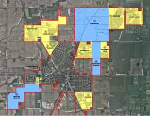
Indeed, there are many obstacles to the village’s intentions as pointed out by those older residents. As shown below, Manhattan’s residential growth is currently set on course with the trend of multi- and single-family residential developments and zoning for general and local shopping, as well as business parks are situated along some major corridors, namely Route 52.
The population’s rapid growth has already overwhelmed the school district, with the opening of a new Manhattan Junior High School. The demand for more business opportunity and housing seems imminent in Manhattan, and the conceptual master plan seems to understand a diversification of those needs. Architectural renderings developed by the Farnsworth Group show plans for mixed-use residential and commercial complexes along both State and North Streets.
Another blockade to the Village’s intentions is developing a transportation system to connect residents in the far away neighborhoods to the central business district: a problem which was initially aided by the opening of the Wauponsee Glacial Trail running on the western side of downtown near Route 52. The heavy traffic, which passes through downtown daily continually dissuades new business in the district as many families are intimidated by the approximately 800 trucks among approximately 9,000 vehicles which pass between the Hoerrmann and Schroeder-Bergan Buildings daily. Developing a safe alternative to vehicular traffic while diverting heavy truck traffic and also making the downtown safer to pedestrian travel and large gatherings seems to be a top priority for the developers of the downtown master plan.
The Village lies in a precarious position between maintaining a positive public image and making necessary improvements to the aging community. However, they seem to be knowledgeable in balancing the valuable criticisms of their older residents while also appealing to the growing voices of younger adults and families.
Manhattan is an important part of the history of Will County and continues to be so today as it is a gateway from the suburbs to the rurality of the greater Illinois, but its story is also the same as many of the county’s closest neighbors. Can such a village handle the pressures of a new era of settlement?
Certainly, the suburban fever has its grasp on Manhattan, tightening and tightening its hold on the humbly rooted farming community with every passing year. Despite this, the one thing that Manhattanites never lost and will likely never lose is their kindness and the friendships which bring them together every year to convene on such integral issues to their growing community.
Links and References:
- Manhattan Memories by the Manhattan Township Historical Society (Revised edition 2017)